Overview
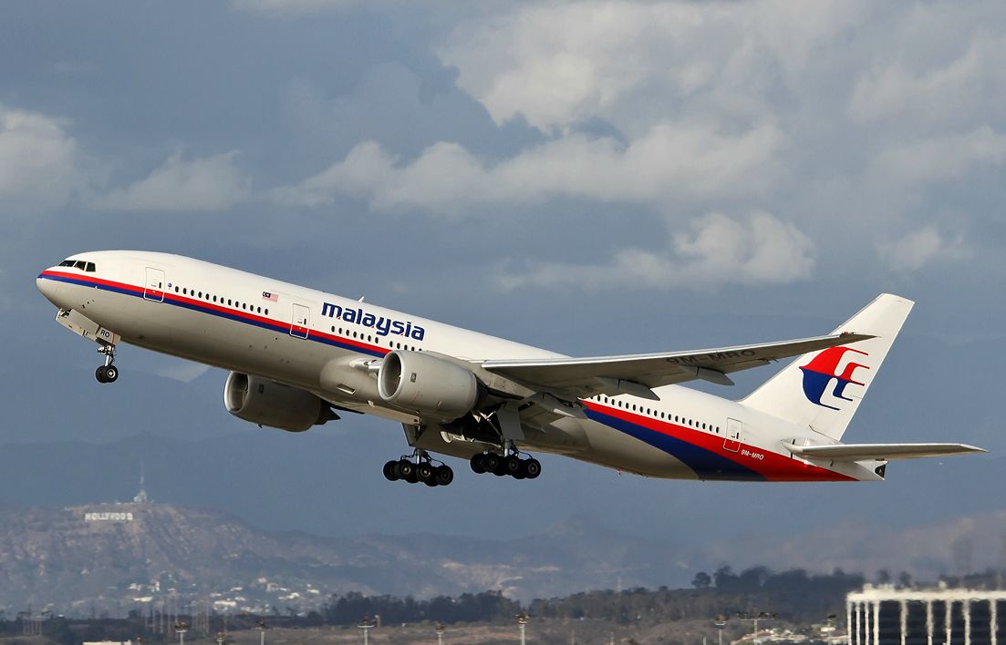
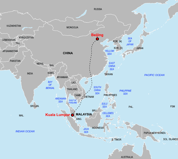
Malaysia Airlines Flight 370 (MH370) was a usual scheduled passenger flight from Kuala Lumpur (ICAO: WMKK) to Beijing (ICAO: ZBAA). The aircraft scheduled for the flight and the one involved in this incident was a 12 year old (11 years and 10 months old to be precise) Boeing 777-200ER wide-body aircraft with registration 9M‑MRO which had flown for about 53,471.6 flight hours with 7,526 takeoffs and landings cycles without any major serious accidents prior to the flight on March 8, 2014. On the fateful day, there were 239 people on board flight MH370 including 2 pilots and 10 crew who were later presumed lost on 29 January 2015 by the Malaysian Government.
Flight Timeline
Previous Flight:
On the day before the disappearance, the same Boeing 777-200ER (Reg. 9M-MRO) had flown it's regular scheduled flight from Beijing to Kuala Lumpur as Malaysia Airlines Flight 371 (MH371) and safely arrived at the destination at approximately 22:30 (MYT) local time on 7th March, 2014. MH371 had departed in the late evening of 7th March 2014 (CST) from Beijing with no delay and were then cleared onto standard airway route towards Southeast Asia and after initial climb, the aircraft cruised at FL350 (35,000 feet above sea level) and the crew found nothing abnormal in the aircraft. MH371 then crossed Mainland China, South China Sea and then approached Malaysian FIR (Flight Information Region) with no reported issue. As they got closer to the destination MH371 began it's descent and arrived at Kuala Lumpur International Airport (ICAO: WMKK) after the approx. 6 and half hour flight at approximately 22:30 local time. The landing was completely normal and no issues where recorded or felt by the crew. The passengers where then disembarked and routine checks and turnaround process was started and the crew of the flight MH371 signed off for the night. The flight from Beijing was completely uneventful and none of the issues or signs of issue related to transponder or SATCOM or ACARS that will happen in the later flight of MH370 where reported in this flight.
Flight MH370:
The new crew who's going to be flying the leg to Beijing arrived to the aircraft and started preparing for the flight. The maintenance engineers inspected the aircraft and the aircraft was signed off as airworthy.
Crew of MH370:
The pilots who were flying this flight was Captain Zaharie Ahmad Shah and First Officer: Fariq Ab Hamid. The captain was a 52 year old Malaysian citizen and had approximately 18,365 of total flight hours from which 8,659 hours was on the Boeing 777. He had joined Malaysia Airlines in 1981 and was one of Malaysia Airline's most senior and experienced captains and had also served as Boeing 777 instructor and examiner. All of his medical, license and simulator checks were current and valid.
The First Officer was a 26 year old Malaysian citizen with approximately 2,763 hours of total flight time of which approx. 177 hours where on the Boeing 777 while the majority of the flight hours were in Boeing 737. He had joined Malaysia Airlines in 2007 and transitioned to the Boeing 777 in late 2013 few months prior to the incident. The MH370 flight was a part of his final line training phase. Though he was relatively new on the B777, he was fully qualified for flying and all the medical and licensing were fully compliant.
Cabin Crew: There were 10 Cabin Crew members on this flight of which 6 were Malaysian, 3 Chinese and one French all were fully licensed and within legal duty limitations.
Flight MH370 startup and take-off:
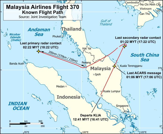
Since the First Officer, Fariq Ab Hamid was the Pilot Flying for the intial part of the flight, he was preparing the cockpit for departure and Captain Zaharie Ahmad Shah completed walk-around inspection on the aircraft and returned to the cockpit with no issues or defects reported. Then after boarding passengers, refueling and everything at approximately 00:20 local time, the crew received the IFR clearance and then after few minutes they were cleared for pushback and at approximately 00:35 they started taxing to runway for departure. At 00:42 local time (MYT) MH370 took off from runway 32R and was cleared for initial climb to FL180 (18,000 feet). Then shortly after, MH370 was transfered from Kuala Lumpur airport frequency to Lumpur Radar who then cleared MH370 to FL350 (35,000 feet above sea level). At 01:01 local time MH370's crew reported that they had reached FL350 which was ackownledged by Lumpur Radar. And at 01:08 the crew of the MH370 again reported that they have reached FL350.
Communication lost:
At 01:06 local time, MH370 transmitted its final automated position report through Aircraft Communications Addressing and Reporting System (ACARS) protocol. As per the final transmitted data there was 43,000 kg (96,600 lb) of total fuel remaining. Then at 01:19:30 local time, Captain Zaharie Ahmad Shah transmitted the last verbal signal to ATC.
Lumpur Radar: "Malaysian three seven zero, contact Ho Chi Minh one two zero decimal nine. Good night."
MH370: "Good night. Malaysian three seven zero."
The crew was expected to check in with Ho Chi Minh City ATC as MH370 passed into Vietnamese airspace. But it didn't happen and from that movement MH370 would become the greatest mystery in aviation history.
Since MH370 never made contact with Vietnam ATC at scheduled time, they informed Kuala Lumpur ATC that MH370 hasn't contacted them and also nowhere to be found in the expected radar. At the same time both ATC reached out to aircrafts nearby the last known position of MH370 and requested them to try to reach out to MH30 using emergency frequency (popularly known as guard frequency) at (121.5 MHz). Following this request, a captain of another aircraft attempted to contact MH370 shortly after 01:30 local time and was able to establish communication with MH370 but only heard static.
Final Radar Contacts
At 01:20:31 local time (MYT) MH370 was observed on the secondary radar at the Kuala Lumpur ACC (6°56′12″N 103°35′6″E) in the Gulf of Thailand and five seconds later it disappeared. At 01:21:13 local time MH370 disappeared from both Kuala Lumpur ACC and Ho Chi Minh ACC. The final transmitted data indicated that the aircraft was flying at the assigned cruise altitude of FL350 (35,000 feet above sea level) and was flying at the speed of 471 knots (872 km/h or 542 mph).
At the time MH370's transponder stopped transmitting, the Malaysian military's primary radar showed Flight 370 turning right, but then beginning a left turn to a southwesterly direction. From 01:30:35 until 01:35, military radar showed Flight 370 at 35,700 ft on a 231° magnetic heading, with a ground speed of 496 knots (919 km/h or 571 mph). MH370 then continued across the Malay Peninsula, fluctuating between 31,000 and 33,000 ft in altitude.
A civilian primary radar at Sultan Ismail Petra Airport with a 60 nmi (110 km or 69 mi) range made four detections of an unidentified aircraft between 01:30:37 and 01:52:35 local time. The tracks of the unidentified aircraft are "consistent with those of the military data". At 01:52 local time, MH370 was detected passing just south of the island of Penang. From there, the aircraft flew across the Strait of Malacca, passing close to the waypoint VAMPI, and Pulau Perak at 02:03 local time, after which it flew along air route N571 to waypoints MEKAR, NILAM, and possibly IGOGU. The last known radar detection, from a point near the limits of Malaysian military radar, was at 02:22 local time, 10 nmi (19 km or 12 mi) after passing waypoint MEKAR (which is 237 nmi (439 km; 273 mi) from Penang) and 247.3 nmi (458.0 km; 284.6 mi) northwest of Penang airport at an altitude of 29,500 ft.
MH370 Missing:
At 02:03 local time, Kuala Lumpur ACC relayed to Ho Chi Minh ACC information received from Malaysia Airlines' operations centre that MH370 was in Cambodian airspace. Ho Chi Minh ACC contacted Kuala Lumpur ACC twice in the following eight minutes asking for confirmation that Flight 370 was in Cambodian airspace. At 02:15 local time, the watch supervisor at Kuala Lumpur ACC queried Malaysia Airlines' operations centre, which said that it could exchange signals with MH370 and that MH370 was in Cambodian airspace. Kuala Lumpur ACC contacted Ho Chi Minh ACC to ask whether the planned flight path for Flight 370 passed through Cambodian airspace. Ho Chi Minh ACC responded that Flight 370 was not supposed to enter Cambodian airspace and that they had already contacted Phnom Penh ACC (which controls Cambodian airspace), which had no communication with MH370. Later, another Malaysia Airlines aircraft (MH386 bound for Shanghai) attempted, at the request of Ho Chi Minh ACC, to contact MH370 on the Lumpur Radar frequency – the frequency on which MH370 last made contact with Malaysian air traffic control – and on emergency frequencies but the attempt was unsuccessful. At 05:30 local time, after more than four hours after communication lost with MH370, the watch supervisor at Kuala Lumpur ACC activated the Kuala Lumpur Aeronautical Rescue Coordination Centre (ARCC) which is a command post at an Area Control Centre that coordinates search-and-rescue activities when an aircraft is lost.
Satellite Communications:
After the final ACARS transmission at 01:06 local time, the aircraft's satellite communication system went offline (speculated possibly due to a power interruption). At 02:25 local time, while over the Andaman Sea, the system unexpectedly rebooted and sent a log-on request to Inmarsat's satellite network.
For the next six hours, the system responded to hourly automated status requests from Inmarsat and received two unanswered ground-to-aircraft phone calls (at 02:39 and 07:13 local time). The final status exchange occurred at 08:10 nearly two hours after MH370's scheduled Beijing arrival.
At 08:19:29 local time, the aircraft sent a final log-on request, followed eight seconds later by a log-on acknowledgement at 08:19:37 local time. This was the last data ever received from MH370. The aircraft failed to respond to Inmarsat's next status request at 09:15 local time and after, communcation and where-abouts of MH370 was completely lost.
Presumed crashed:
Malaysia Airlines issued a statement at 07:24 MYT on March 8 an hour after MH370's scheduled Beijing arrival announcing that contact had been lost at 02:40 (later corrected to 01:21) local time. But unbeknownst to anyone at the time, the aircraft was still airborne over the Indian Ocean when this statement was released, though initial search efforts focused on the South China Sea. The crew and communication systems had relayed no distress signal, weather concerns, or technical problems before vanishing from radar.
On March 24, Malaysian Prime Minister Najib Razak announced at 22:00 local time that analysis by the Air Accidents Investigation Branch and Inmarsat had concluded MH370's final position was in the southern Indian Ocean, where no landing sites exist. Malaysia Airlines immediately declared the flight lost with no survivors, notifying families in person, by phone, or via SMS. On January 29, 2015, Malaysia's Director General of Civil Aviation officially changed MH370's status to an "accident" under the Chicago Convention on International Civil Aviation, with all 239 passengers and crew presumed dead.
Search for MH370:
A search-and-rescue effort launched immediately in Southeast Asia, but shifted to the southern Indian Ocean one week later following satellite data analysis. Between March 18 and April 28, 2014, 19 vessels and 345 military aircraft sorties searched over 4.6 million square kilometers. The initial surface search (March 18-27) focused on a 315,000 square kilometer area about 2,600 kilometers southwest of Perth—a region Australian Prime Minister Tony Abbott described as "as close to nowhere as it's possible to be," notorious for fierce winds, hostile seas, and extreme depths. Revised radar tracking and fuel calculations prompted two major search area shifts on March 28 and April 4. Between April 2-17, vessels including Australia's Ocean Shield, China's Haixun 01, and HMS Echo rushed to detect underwater locator beacons from MH370's flight recorders before their batteries expired. Several acoustic signals matching the frequency of flight recorder "pingers" were detected April 4-8, but a subsequent sonar search of the seafloor found nothing—made worse by the later revelation that the flight data recorder's beacon battery may have expired in December 2012.
The underwater search phase, announced in late June 2014 and coordinated by Australia's Joint Agency Coordination Centre (JACC) with support from Malaysia and China, focused on seafloor bathymetry and sonar scanning approximately 1,800 kilometers southwest of Perth. A preliminary bathymetric survey charted 208,000 square kilometers of seafloor between May and December 2014. The main deep-water search began October 6, 2014, with Malaysia, China, and Australia jointly committing to search 120,000 square kilometers along the seventh arc. Three vessels towed side-scan sonar, multi-beam echo sounders, and video cameras, while a fourth vessel deployed autonomous underwater vehicles from January to May 2015. On January 17, 2017, the official search—the most expensive in aviation history—was suspended after finding no trace of the aircraft beyond debris washing ashore on African coastlines. The operation cost $155 million (Malaysia 58%, Australia 32%, China 10%), with 86% spent on the underwater search. Investigators had narrowed the probable crash site to 25,000 square kilometers using satellite imagery and debris drift analysis.
In October 2017, Ocean Infinity offered to resume the search, and Malaysia approved the mission in January 2018 on a no-find, no-fee basis. The company chartered Seabed Constructor, which reached the search zone on January 21 and began scanning at 35.6°S 92.8°E—the most likely crash site according to drift modeling by Australia's CSIRO. Ocean Infinity planned to search an initial 33,012 square kilometers in "site 1," with potential expansion to 48,500 additional square kilometers. As the search progressed, "site 4" was added farther northeast along the seventh arc. By late May 2018, eight autonomous underwater vehicles had covered over 112,000 square kilometers across all four sites. Malaysia's Transport Minister Loke Siew Fook announced the search would end in May 2018 before seasonal weather made operations impossible. Ocean Infinity's contract concluded on May 31, and the search officially ended June 9, 2018, with no wreckage found. The seafloor mapping data was donated to the Nippon Foundation-GEBCO Seabed 2030 Project.
In March 2019, marking the fifth anniversary of MH370's disappearance, Malaysia stated it would consider any "credible leads or specific proposals" for a new search. Ocean Infinity expressed readiness to resume operations on the same no-find, no-fee terms, citing experience gained from successfully locating Argentina's submarine ARA San Juan and the bulk carrier Stellar Daisy. The company believed the aircraft remained somewhere along the seventh arc in the previously identified zone.


Ocean Infinity's Continued Search:
In March 2022, Ocean Infinity committed to resuming the search in 2023 or 2024 pending Malaysian government approval. Throughout 2023, the company reviewed data from its 2018 search to ensure nothing had been missed. CEO Oliver Plunkett hoped to deploy Ocean Infinity's new Armada vessels by mid-2023, but Malaysia's Transport Minister Wee Ka Siong requested credible new evidence before approving another mission evidence Plunkett reportedly possessed. These claims prompted families to renew their push for another search. In March 2024, days before the tenth anniversary of the disappearance, Malaysia announced it would consult with Australia about collaborating on another Ocean Infinity expedition.
On May 2, 2024, Ocean Infinity submitted a new search proposal to Malaysian Transport Minister Anthony Loke. On December 20, 2024, the Malaysian government announced it would resume the search for MH370, with Ocean Infinity covering a refined 15,000 square kilometer area in the southern Indian Ocean at an expected cost of $70 million on a "no find, no fee" basis—meaning payment only if substantial wreckage is located.
Minister Loke confirmed on February 25, 2025, that Ocean Infinity had officially resumed the search using Armada 78 06, one of eight identical 78-meter vessels from Ocean Infinity's revolutionary Armada 78 fleet. The vessel departed Mauritius on February 23 and reached the search zone shortly thereafter, beginning operations at the primary target coordinates. These purpose-built robotic survey vessels represent a quantum leap from the 2018 search technology. Armada 78 06 operates with minimal crew (as few as 16 personnel) while being monitored and controlled from Remote Control Centers in Southampton, UK and Austin, Texas. The vessel features dual moonpools through which three HUGIN autonomous underwater vehicles are deployed simultaneously. Each capable of diving to 6,000 meters and operating for over 100 hours, roughly twice the endurance of the 2018-generation robots. The AUVs are equipped with side-scan sonar, synthetic aperture sonar, multibeam echosounders, and high-resolution cameras capable of identifying objects as small as a suitcase on the seafloor. Onboard AI systems can analyze sonar returns and prioritize anomalies in under 20 minutes-a process that once took hours or days.
However, on April 3, 2025, Minister Loke announced that Ocean Infinity had suspended operations due to seasonal weather conditions in the southern Indian Ocean 10-meter swells and fierce winds that make deep-sea operations impossible during autumn and winter months. Before halting operations, Armada 78 06 had completed a 2 phase search in the Indian Ocean.
The mh370-caption.net team is posting their researches and MH370 related information in their site and also has made a page to track Armada 78 06 vessel's survey path with all details which is available here https://www.mh370-caption.net/index.php/armada-tracking/. Do check it out! (Not affiliated to us BTW).
Tracking Armada Vessels:
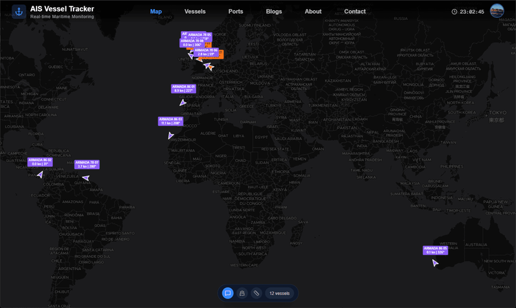
On our AIS Vessel Tracker along with 350,000+ vessels you can now track all the vessels in the Ocean Infinity's Armada 78 & 86 fleet like shown in the image below. We can expect any one of these vessels to be relocated to Indian Ocean prior to the search. Stay tuned and we'll keep you updated regarding this.
We're also very curious much in MH370's search and we'll be posting updates about it so follow us in our socials to get notified!
Social Links:
Instagram: https://www.instagram.com/voyage_radar/
Facebook: https://www.facebook.com/profile.php?id=61583019390576
X (Twitter): https://x.com/VoyageRadar_VT
LinkedIn: https://www.linkedin.com/company/voyage-radar
Update: Ocean Infinity's Armada 86 05 vessel was seen leaving the coast of Fremantle on 23th December 2025 around 13:00 UTC and has reached the search area approximately on 30 December 19:00 UTC and started the search on the ocean floor with it's AUVs (Autonomous underwater vehicle) and is expected to search about 15,000 square km in the Indian Ocean. As of 13th January 2026 nothing unusual was found and Armada 86 05 is expected to depart from the search site in about 2 days for a port call in Fremantle for crew change and resupply after which the search will resume in few days. Track Armada 86 05 on Voyage Radar: https://aisvesseltracker.com/?mmsi=563283200